MISSION 020725
NC4ES – N4PRS – NC8TF PICO BALLOON LAUNCH
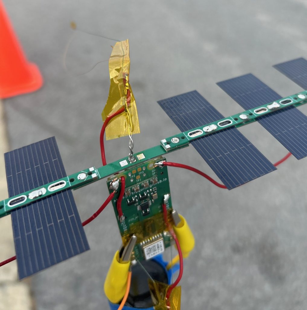
NC4ES is the amateur radio club dedicated to supporting the Eastern Healthcare Preparedness Coalition, combining unique technical skills with a commitment to healthcare preparedness. While it may seem that launching pico balloons has little to do with healthcare, the expertise developed through this activity plays a critical role in enhancing the capabilities of our team and its partners. This project fosters a range of important skill sets, including:
- Team Building: Collaborating on complex projects like balloon launches strengthens teamwork and coordination, essential qualities for disaster communication support.
- Design, Implementation, and Hardware Development: Our team designs and builds the necessary equipment for the launches, including custom radio transmitters and balloon payloads, providing invaluable hands-on engineering experience.
- Radio Signal Propagation Experimentation: Testing how radio signals behave at varying altitudes helps refine communication strategies, crucial for emergency preparedness and disaster response in remote or hard-to-reach areas.
- Public Engagement and Education: Launching a pico balloon is a long-term project that captivates public interest. The unusual nature of the activity and its connection to a significant cause create an opportunity to educate the community on how amateur radio supports disaster communications.
A number of NC4ES team members are also pilots, bringing an added layer of expertise to the project. We thrive on the challenge of pushing the boundaries of what’s possible, striving to design and launch amateur radio transmitters that go higher, farther, and lighter than ever before. Each launch is an opportunity to test new limits and build on previous successes. This project is volunteer in nature and any costs are covered by the participating members and supporting clubs.
We keep the public informed by posting updates on social media and on this page after each launch, so you can follow along with the exciting progress of our work. Each balloon launch brings us one step closer to improving our communication capabilities in times of need, ensuring we are always ready to support our community.
NC4ES-8 (Balloon for EHPC – NC4ES Team) – 8th launch
N4PRS-11 (Balloon for Pamlico Amateur Radio Society) – 1st launch
NC8TF-11 (Balloon for Task Force 8 Urban Search and Rescue Team) – 1st launch
How are we allowed to launch a balloon? Isn’t it dangerous to aircraft? Please read Code of Federal Regulations 14 CFR Part 101
This is the section of the Code of Federal Regulations that allows us to fly Amateur Radio Pico Balloons 14 CFR Part 101.
List of Countries Flown Over to date: Western Sahara/Morocco, Mauritania, Mali, Algeria, Libya, Egypt, Israel, Jordon, Saudi Arabia, Iraq, Iran, Afghanistan, Pakistan, Nepal, Tibet, China, South Korea, Japan, Mexico.
The first circumnavigation was completed on the evening of February 16, 2025
LINKS FOR TRACKING NC4ES-8:
PAYLOAD IS HEALTHY
*NOTE- TRAQUITO SITE (PRIMARY) IS THE MOST ACCURATE*
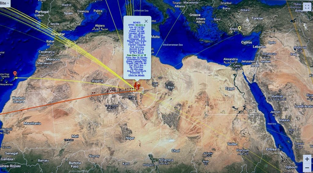
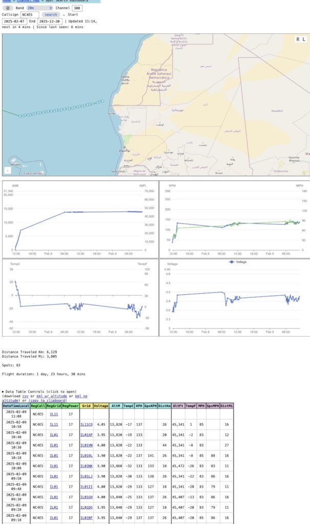
PRIMARY- TRAQUITO SITE TRACKING (SHOWS TELEMETRY): NC4ES BALLOON TRACKING ON TRAQUITO
SECONDARY- LU7AA TRACKING ON NC4ES: CLICK HERE FOR LU7AA TRACK ON NC4ES
ADDITIONAL MAPPING- SONDEHUB: CLICK HERE FOR NC4ES ON SONDEHUB
APRS (APRS.FI) MAPPING-CLICK HERE FOR APRS MAP INFO

LINKS FOR TRACKING N4PRS-11:
PAYLOAD IS HEALTHY
PRIMARY- TRAQUITO SITE TRACKING (SHOWS TELEMETRY): N4PRS BALLOON TRACKING ON TRAQUITO
SECONDARY- LU7AA TRACKING ON N4PRS-11: CLICK HERE FOR N4PRS-11 TRACK ON LU7AA
ADDITIONAL MAPPING- SONDEHUB: CLICK HERE FOR N4PRS-11 ON SONDEHUB
APRS (APRS.FI) TRACKING: APRS TRACKING FOR N4PRS-11 (APRS.FI)
***LINKS FOR TRACKING WU2V-11 (Launched 03-12-25 @ 13:00)***
PAYLOAD IS HEALTHY
PRIMARY- TRAQUITO SITE TRACKING (SHOWS TELEMETRY): WU2V-11 BALLOON TRACKING ON TRAQUITO
LU7AA TRACKING: LU7AA TRACKING FOR WU2V-11
SONDEHUB Tracking: WU2V-11 on SONDEHUB
APRS.FI TRACKING FOR WU2V-11 APRS INFO FOR WU2V-11

WU2V-11 launched from the Regional Operations Center on 3-12-25. Calm winds allowed the rig to rise almost straight up to about 3500ft before departing towards the East. The rig settled in at 46,395ft the evening of 3-12-25. Upon wake up, the rig was 2200 miles downrange heading to Africa.
________________________________________________________________________________________________________________
Below are updates of the missions starting with the most recent activity – (Will try to post a daily summary):
3-1-25 Weekly Update: Radio Balloon Mission
Both rigs are performing well and reporting as expected. They are now thousands of miles apart.
NC4ES-8 has taken a more northern route, crossing the North Atlantic near Iceland over the past two days. As of this morning, it is just south of the UK, off the coast of France.
N4PRS-11 remains ahead, locked into the main jet stream at high speed. Currently flying over the Red Sea, it is on track to cross southern Asia soon. If all goes well, N4PRS-11 could return to CONUS by the next update.
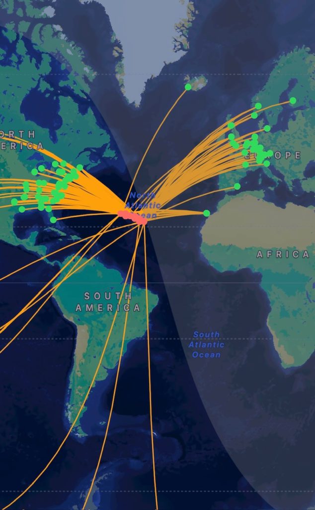
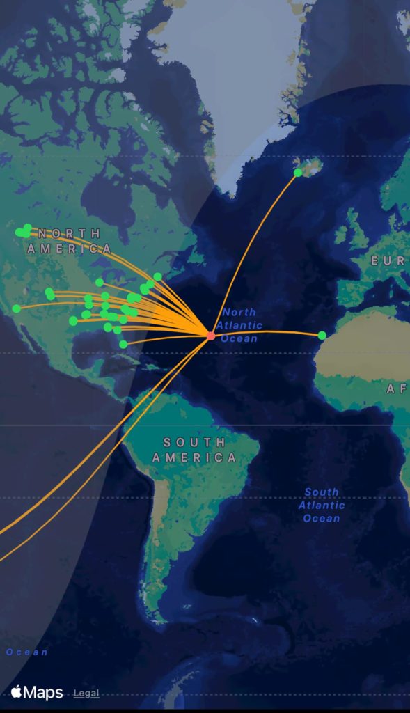
The attached graphics show each balloon’s current position, the 96-hour track forecast, and previous lap tracks. Additionally, one image highlights N4PRS-11’s record-setting journey—covering over 50,000 miles in just 22 days, an impressive pace. We are producing power down to about 11 degrees solar elevation (not bad).
Both balloons are now on their third lap around the globe. Their altitudes have slightly increased, generally ranging between 43,000 and 45,000 feet, depending on atmospheric pressure. The next few thousand miles will be challenging due to GPS jamming and limited ground station coverage.
Stay tuned for the update next week!
2-23-25: Weekly Update: Radio Balloon Mission
We’re now over halfway through our second lap around the Earth! 15 days of flight and about 36,000 miles traveled.
N4PRS-11 has surged ahead, cruising at around 43,000 feet in the main jet stream at speeds of 150-170 mph. Currently East of Japan. Meanwhile, NC4ES-8 has opted for the scenic route, drifting over lower Mongolia—perhaps pausing to take in some throat singing from the mountain peaks (but I could be wrong).
The last few thousand miles have been quiet, with only one station deep in central Russia decoding its signal. NC4ES-8 has lost a little bit of altitude but remains steady at 42,000-43,000 feet, moving at a more relaxed 70 mph.
The latest 48-hour tracks are up, and here’s where things stand:
• N4PRS-11 should return to the mainland within 48 hours.
• NC4ES-8 seems to have its sights set on Alaska first, may get stuck in the Arctic track.
It’s fascinating to see how two balloons, launched just five minutes apart, are now thousands of miles away from each other—all due to a 1,000-foot altitude difference.
Let’s see where they end up next week! ![]()
![]()

2-16-25: Today’s the Day – A Record-Breaking Milestone!
After an incredible journey, we’ve shattered records and are set to cross the “start” (Longitude line) this evening, marking a major achievement in this mission’s first circumnavigation.
Quick Mission Summary:
• Countries Flown Over: Western Sahara/Morocco, Mauritania, Mali, Algeria, Libya, Egypt, Israel, Jordan, Saudi Arabia, Iraq, Iran, Afghanistan, Pakistan, Nepal, Tibet, China, South Korea, Japan, Mexico.
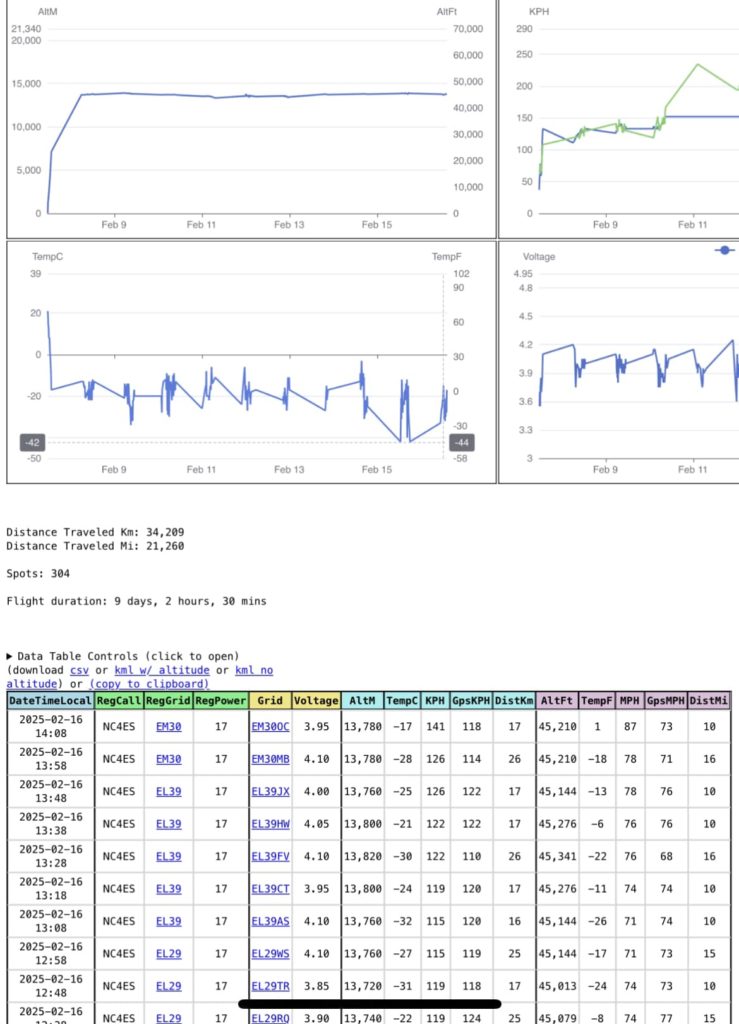
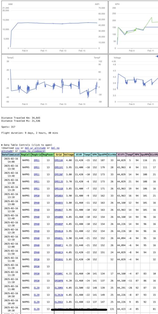
• Distance Traveled: 21,536 miles (final count coming tomorrow).
• Total Time: 9 days, 2 hours, 40 minutes. (Our previous record was 14 days).
• Average Altitude: 43,000 – 46,000 ft.
• Average Speed: 90+ mph.
• Highest Recorded Speed: 175 mph.
Race to the Line:
N4PRS-11 (Pamlico Co) is on track to cross first, claiming the “winner” title, while NC4ES-8 trails by about 250 miles due to higher altitude and slightly lower wind speeds. Both rigs remain in excellent condition.
What’s Next?
Tonight, we kick off Lap 2 around the globe! Updates will now shift to weekly, as the focus turns to endurance. Our goal? Breaking our record of 7 laps.
Stay tuned—NC8TF will be launching their balloon in the next week or two to join the adventure. The journey continues!
First two pics are of NC4ES telemetry and location. Other two are N4PRSs data.
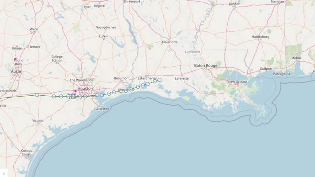
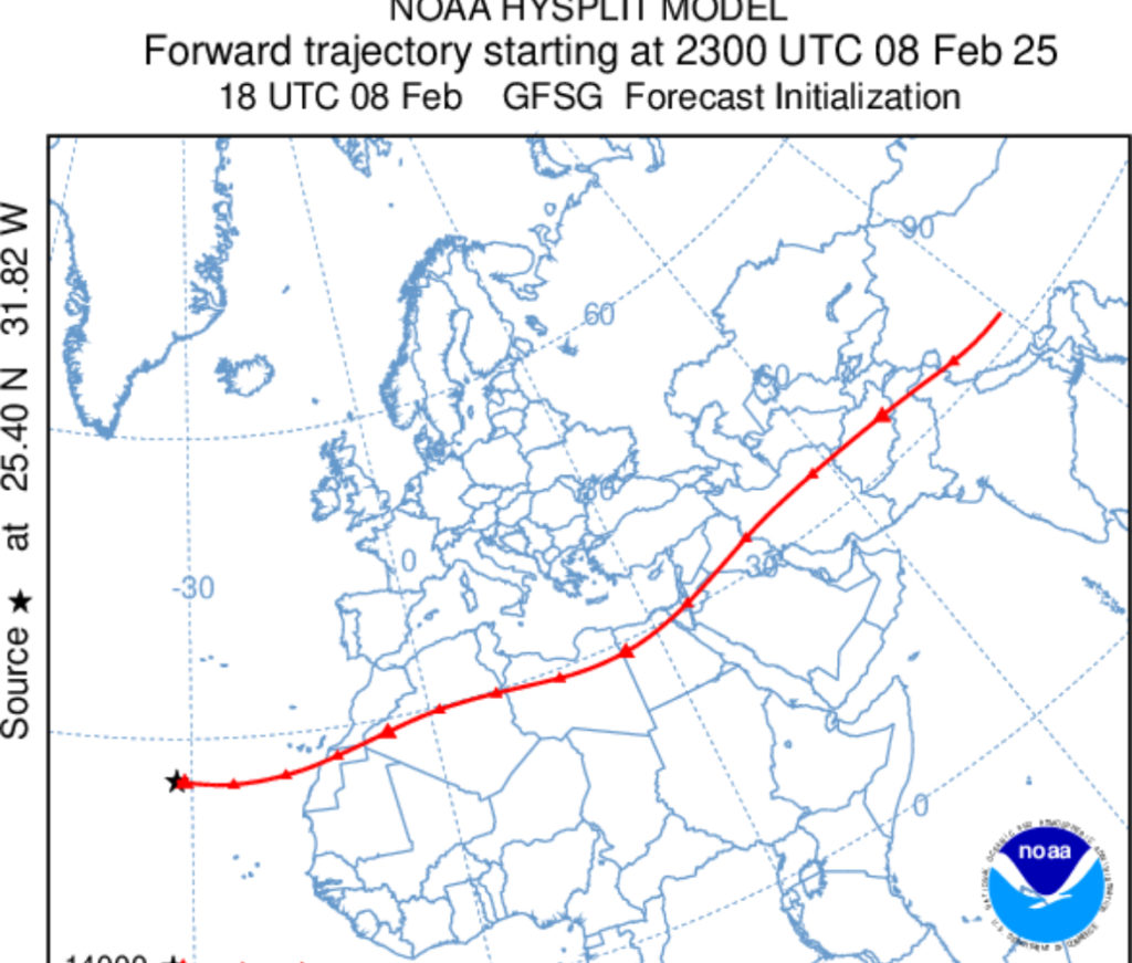
2-14 and morning of 2-15 2025 summary: It was a fairly quick trip across the Pacific. After a short venture North, both payloads made it back to the CONUS the evening of 2-14-25. Speed has slowed due to a significant low pressure system off the Baja. Both rigs passed around the North of the system. As of this writing, NC4ES is near the Southern California area. N4PRS is down near the Baja area of Mexico. Both rigs look like they have cleared the low pressure pot hole and should start to gain speed now as they transition back into the jet stream. Both should be crossing the finish line in the early morning of 2-17-25. We will have to calculate the time, but it may be a record. It sure will be a record for our team with a 9-10 day circumnavigation time. The look ahead has the rigs going to the middle Atlantic and hopefully a turn back to the South (Africa).
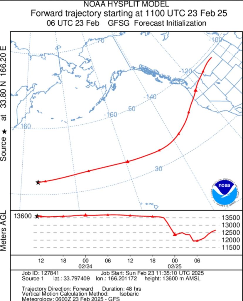
2-13-25: Both payloads woke up near the same location. We are about 600 miles NW of HI (Oahu). Currently riding in the main jet stream with winds estimated at 125mph. Receiving stations are very slim to start. HI, JA and AU the only reporting stations. As the day progresses, hopefully we will get some West coast stations to report. Altitude looks good on PRS, still holding 43,600ft or so. As of this writing, we are still awaiting altitude telemetry from NC4ES. Graphics are provided below on 48hr and 96hr forecast tracks. Looks like they are forecast to fly over the launch site (Greenville NC) on Sunday 2-16-25. If you have a radio to decode WSPR- you should be able to hear them go by or on the approach/departure!
We are on track to beat our previous record of 14 days for circumnavigation. If everything stays on track, we should be across the line in 9-10 days of flight time. We will calculate the average speed based on the miles traveled once the line is crossed.
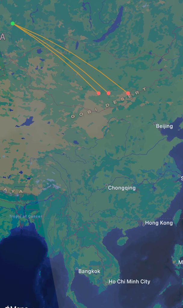
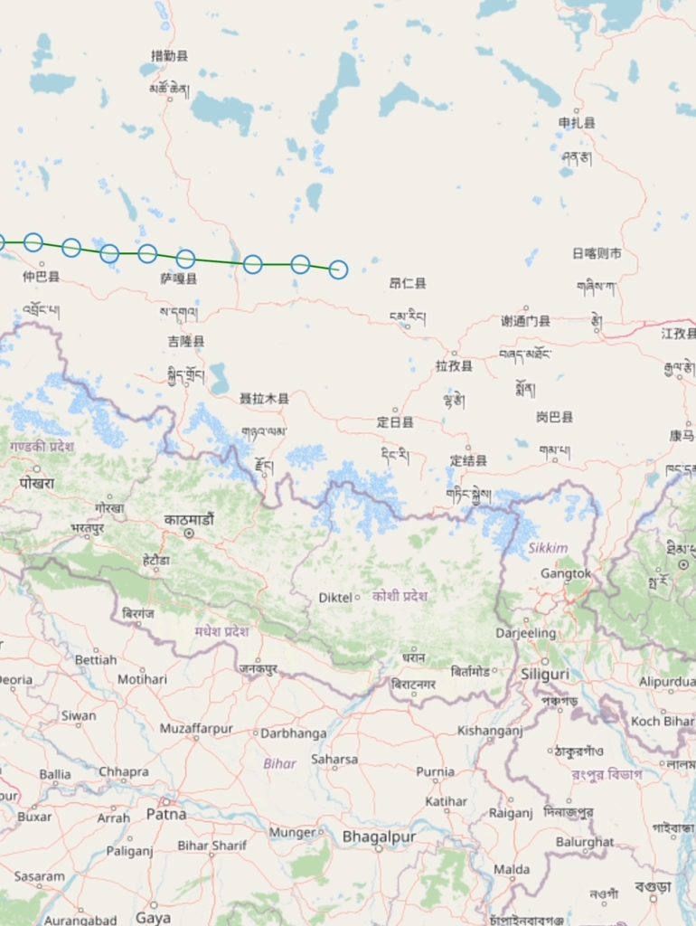
2-12-26: Both payloads are cruising ahead quick. At sunset, they both had transitioned across the Himalaya’s (NC4ES-8 just passing about 60 miles North of Mount Everest). As of this writing they both should be in mainland China and rapidly cruising towards South Korea/Japan. We are in the center of the jet stream and could not ask for better positioning. We may be on track for a record on the speed of the first circumnavigation. As of today, we have been in flight for 4 days, 18 hours and traveled 10,670 miles before going to sleep. We are just about 1/2 way around the world. The look ahead actually has us speeding up near Japan and should pass close to Hawaii and back towards the US mainland. Spots may be limited for the next 1000 miles or so until we reach the coast. Japan and Australia are excellent receiving points. We have a few receive stations that are reliable in Central and Siberia parts of Russia. Note- we will make daily updates until we reach the 1st circumnavigation then will transition to weekly updates.
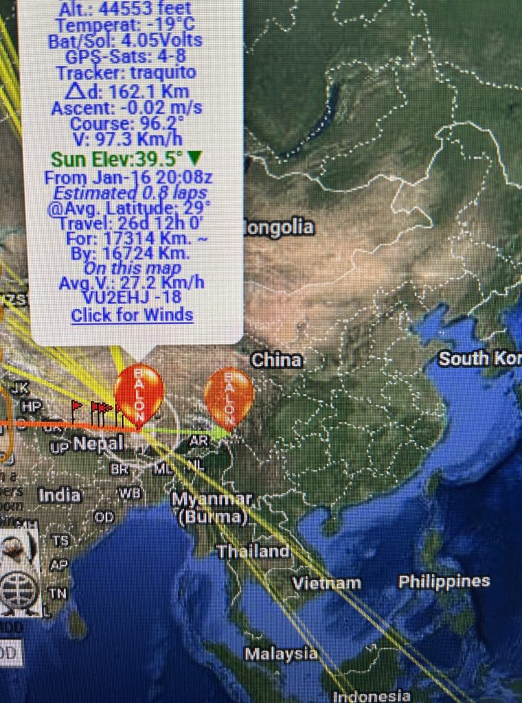
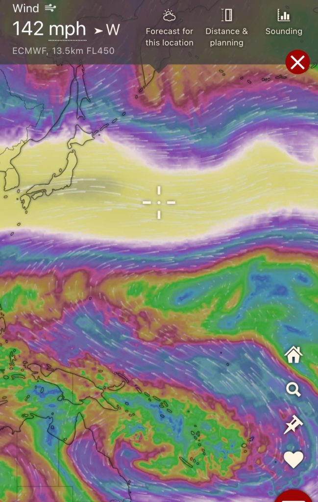
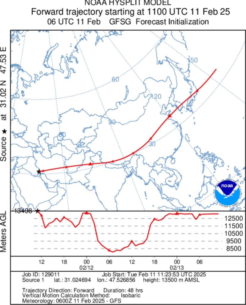
2-11-25: Both payloads made their way across Libya and Egypt over the previous night rather quickly. Upon wake up, both rigs were in Saudi Arabia flying at 95mph ground speed. Altitude is holding in the general area of 43-45k ft. Spots are becoming less frequent as reporting stations become very sparse from this point forward to Japan. We can expect some good grey line spots on the front and back ends along with a few stations in EU/RU during the day. GPS jamming and spoofing has been recently reported over Iran and the path ahead. It would not be abnormal to have some false readings and some days with no spots. Luckily we should be near Japan in the next 48 hours due to a solid ride in the jet stream. Both rigs were South of Tehran (Central/Southern) Iran before going to sleep. The next 48hrs: (Notice the trip over the Himalaya’s with AGL)
2-10-25: The payloads are comfortably flying between 43,700ft and 45,100ft about 100 miles from each other in Libya as of 10:00am EST. As of this writing, there is about 30 minutes of light left before the payloads go to sleep for the night. The track is still consistent with a straight shot over to the S Korea region by the end of the week. Current ground speed is about 95mph with a forecast to increase. We expect to be on the other side of Egypt when wakeup occurs. Still no sign from NC8TF payload. We are prepping another vehicle to get launched and will announce when that occurs.
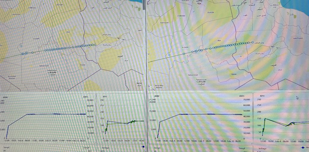
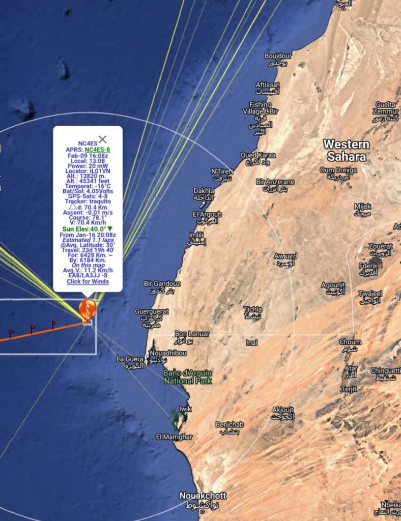
2-9-25 NC4ES-8 and N4PRS-8 are in the same general area and are crossing the beach in the Western Sahara about 11:37am EST. Everything looks healthy and speed is sustained at 80-90mph. Outside temperatures are from -5 to -20F. Few hours of travel left before going to sleep for the night. Current projections should have us by South Korea by the end of the week. We have some interesting travel ahead!
2-8-25 19:30EST: The below graphic is estimated position as of 2-8-25 1930L and the look ahead over the next 96hrs. Each large triangle represents 24hr increments.
2-8-25: Overnight was the most critical phase of flight. Float altitude was reached sometime around sunset most likely over the Atlantic. 20m propagation is intermittent and was somewhat poor in Europe early today. NC4ES was first to report and was almost halfway across the Atlantic already at an altitude of around 45,000ft, moving at 75mph, Outside air temp of 9F and voltage steady. N4PRS reported shortly after slightly lower in altitude, about 44,000ft and similar other data. Both of those units are located in the same grid and it looks like it will be a good even race. Will be interesting to see how close they stay together. NC8TF was not heard from yet (as of 0930am). That payload was a little behind yesterday and we are unsure of it’s status. We hope to hear from it at some point today. It is not unusual to have one just appear a day or two after. Many things can cause this… something as simple as the upper radiator antenna wire is touching a solar panel. We shall see. Otherwise the other two payloads appear to be healthy and now are settled in for the ride. We should move quickly to Africa (by Sunday evening) and hopefully ride the jet stream across Africa, up towards Afghanistan and over to Korea quickly. Winds are 90-140mph in that stream. The Traquito site is the most up to date with telemetry. The trackers went to sleep about 14:00est and had good signal reports all across Europe. It is worth mentioning the farthest spot report at over 11,800 miles away in Australia. Amazing for 20mW:

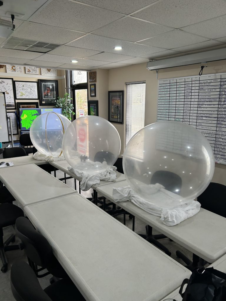
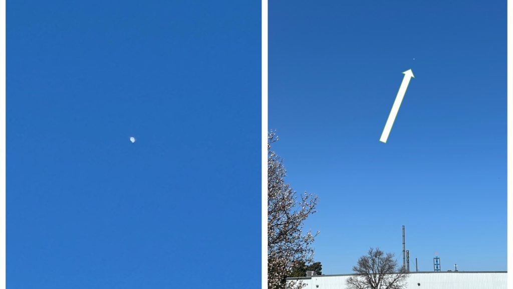
2-7-25: All three payloads were launched about 11am 2-7-25. The weather was perfect for launching along with the winds aloft for a Southern transit to Africa. All three payloads were around 20,000ft AGL and continuing their ascent after lunch. The 20m band degraded in the afternoon and all three payloads had intermittent packets decoded before hitting the sunset out in the Atlantic Ocean. We are hopefully all three are healthy and we will see them on 2-8-25. As long as they reach float altitude, they should be moving fast (120-230mph) headed South of Bermuda tracking towards Africa. Cold night ahead… hopefully not a wet one. Thanks to the members of the Pamlico Amateur Radio Society, EHPC/NC4ES, Pitt County, Durham FD/TF8 and Pitt County Repeater Association for attending.

Link to launch pics and videos: CLICK HERE OFR PHOTOS AND VIDEOS OF LAUNCH
2-5-25: Balloons have been exhausted of air. Payloads have been weighed. Fully loaded 15.2 and 17.4 grams. These are a bit heavy for our liking, but we are continuing with the launch scheduled for Friday 2-7-25 at 11:00am (or so). We are shooting for 6 to 7 grams of free lift at this point.
2-3-25: Balloons have been stretched and the crew continues to look at the weather window for FEB 7th